Before I begin, I just want to say I am typing this at 1:30 am local time and after a very intense chase day, which apparently is a "warm-up" for the storms we are expecting in the upcoming week. Our target for the day was West Kansas, with the SPC forcecasting a slight risk of storms in this area, with a 5% chance of a tornado within 25 miles of any point within this risk area. We had quite a drive up from Amarillo, up through Oklahoma and into Kansas, so we set just before 10 am.
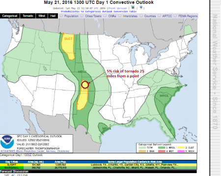
The Storm Prediction Centre Risks for May 21st 2016
We drove until the very early hours of the afternoon, with a brief stop off for lunch at Subway in Liberal, Kansas, the home of Dorothy from the Wizard of Oz. In fact, you can actually visit her house - but there was no time for that as we were set on chasing the expected storms. We positioned ourselves a little further north, stopping to watch what formed over the dryline. Initially we watched in Sublette, moving on to Ulysses and Johnsonville. There were some concern that we were too close to the dryline and also that the cap was too strong, preventing storms from forming. A small attempt at a cell, as seen below, tried to form but quickly died out.
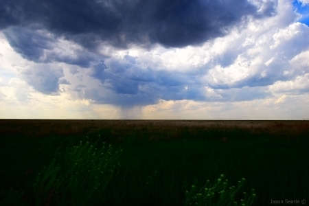
The initial cell that tried hard to develop, but failed miserably - note the central
precipitation, which had hailstones the size of 10 pence pieces within it
As we watched this one die off, we noticed an explosive response on Baron - directly above our heads. Not only did it show great potential to develop into the cell we had been searching for...it was chucking out lightning left right and centre! It also showed signs of rotation (rotation, for those who are not weather savvy and like to see stormy pics and videos, is key in formation of tornadoes and mesocyclonic structures). The cell popped up out of nowhere and in less than 20 minutes became severe-warned.
We sat watching this thing grow and grow. We were within a tornado watch, but with the poor inititiation and the high storm base, we were not expecting to see a tornado drop. As we were close to the dry line, we accepted we would probably only experience some great structure and possibly some large hail. Oh how wrong we were. Following the cell up to Leoti Kansas, we knew we were in for a tremendous treat. Watching the rotation tighten and the RFD whip the rain curtains around, a tornado fought hard to touchdown in front of us. It lasted barely a minute, so missed the most opportune photo, but will feature in some video footage I was capturing at the time. My best shot is seen below.
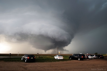
Tornado touching down in Leoti, Kansas - May 21st 2016
Due to the atmsopheric conditions, the storm continued to build and build - but as it sat so close to the dryline - it remained pretty stationary. This made it pretty easy to chase as, well, it wasn't moving! Lightning continued to rain down upon us, as did the hail, as the storm became more and more HP (high precipitate - i.e. wet). After some debating, we head off to try and get north of the storm, but stopped to turn around knowing the journey would be 25 miles through 4 inch hailstones. As we turned, we sat in the bears cage - right below the a huge area of rotation and watched the sweeping rain curtains pass all around us.It was pretty ropey at times, but the adrenaline rush was pretty indescribable. We head back to our original position to then take images of the storm as it died out.
A dying storm never sounds appealing, but the structure of this one can only be described as weather eye-candy. A large mesocyclonic structure throwing out lightning bolts over a scenic US town has to be one of the most incredible sights I have ever seen.
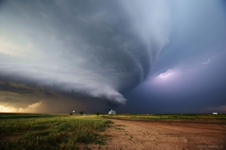
Large Supercell with Inter-Cloud Lightning over Leoti, Kansas
We observed this for a good hour or two before the sun started to set, providing us with an enchanted view of the structure under the storm. Behind us, the cell had some very large and pronounced mammatus clouds (affectionately named "booby" clouds by the chasers). These ones were textbook. Breathtaking to see and although they are very 3D in real life, the lighting from the sun gave the sky the appearance of an oil painting.
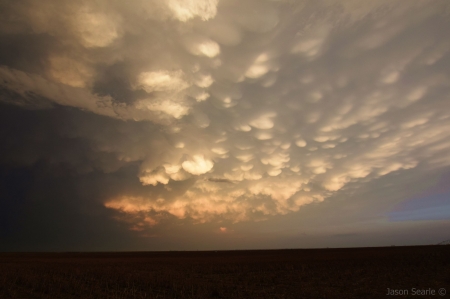
Mammatus clouds in the sunset
As the sun set, the lightning from the storm became more apparent, with forks appearing every couple of seconds. I've always liked the idea of lightning photography at night on a supercell - as it was lightning photography at night that resulted in me initially finding out about these tours. It did take a while to figure out the right settings, but managed to capture a few shots of the dying storm in the dying light.
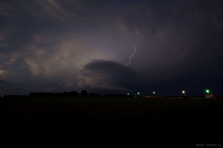
The Dying Storm of Leoti
Our chase finished approximately at 9:30 and Paul suggested we get something to eat and try to position ourselves ready for the risk the following morning. We drove to Garden City, Kansas, for an Applebys and a few beers to celebrate a successful chase day, before crashing at the Sunflower Inn.
Tomorrow's risk looks good - so hopefully I shall bring you more interesting tales and photographs then. If there is time before we set out on the chase, I'll try and upload another post with some video of today.
Make A Comment
Comments (0)